Prologue
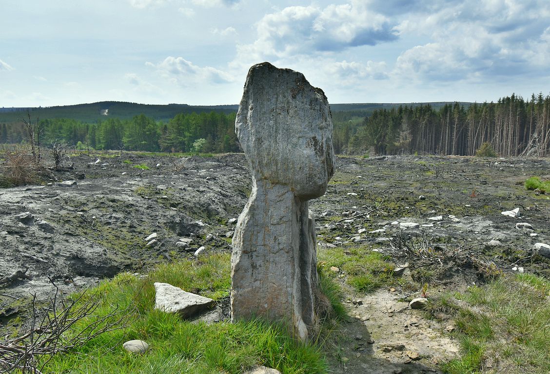
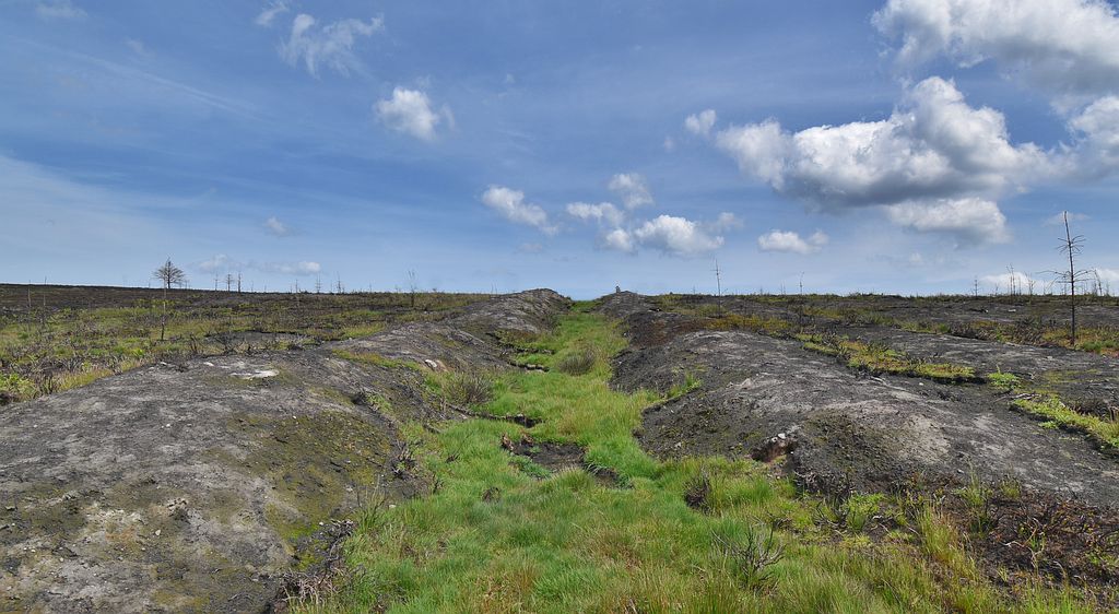
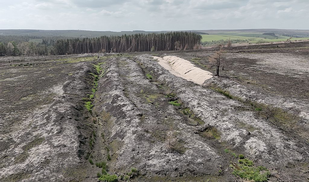
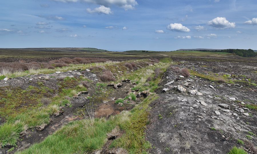
In August 2025, a fire in Langdale forest (on the North York Moors) spread onto the nearby moorland called John Cross Rigg, and the whole area burned for several weeks. The land was closed off for months afterwards, and when it was finally safe to visit the area, it was just an expanse of blackened earth. All the heather had been burnt off, and in large areas all the under lying peat had burned away too. Some how the Old Wife’s Neck stone was unscathed, and there was even grass still growing around it, so it seems to have been protected. While the fire was a disaster for the ecology of the moor, it also revealed a mass of archaeology that lay hidden beneath the carpet of heather. Among the features that are now clearly visible are the series of Bronze Age bank and ditch earthworks which extend for over 750m in an east-west alignment across the moor. The Old Wife’s Neck stone sits on the western end of these earthworks, although their original purpose is unclear.
Back To the Neck
In 2020 i wrote an article about the curiously named standing stone known as the Old Wife’s Neck, which is located on the Bronze Age earthworks running across John Cross Rigg. In more recent times it has been noted that when viewed from certain angles the profile of the stone resembles a human head (female?), with perhaps the implication that it is the head of the ‘Old Wife’ – a figure in local folklore. However, if this is the case then why does the name specify the ‘neck’ of the Old Wife? The name does not really make sense – ‘Old Wife’s Neck’ – the neck of the Old Wife? or the neck belonging to the Old Wife? Does it even refer to a persons neck, or has some confusion crept into the name in the past?
Back in 2020 i suggested an alternative explanation for the name involving the Norse/Scandinavian word ‘Neck’, which means a bundle or sheaf of harvested grain. When viewed from its east side the standing stone could be said to resemble a harvested sheaf tied at the ‘neck’ (see image below). So was this the ‘Neck’ belonging to the Old Wife?

Some support for this idea comes from the similarities between the folklore figure of the Old Wife and the mythological ‘Cailleach’ (a Gaelic name also meaning ‘Old Wife’) who can be found further north in Scotland. As well as having the same name, the Cailleach was closely connected with harvest time rituals -especially the reaping and gathering of grain crops. Both the Cailleach and the Old Wife were giants in some accounts, and they both created features in the landscape, using a mallet or hammer in their work. They were also connected with certain large boulders, which they could throw around with ease, and they were both in the habit of dropping piles of stones from their aprons to form cairns and burial mounds.
Neck or Nick?
In his recent book ‘Scotland’s Sacred Goddess‘ (McHardy, 2025) the author mentions several Gaelic place names called ‘Sgriob na Caillich” – meaning ‘the Old Wife’s Furrow’ or ‘Old Wife’s Scrape’. These names are attached to unusual features in the landscape where the Cailleach is said to have created a long furrow, or trench in the ground. Given the similarities between the Cailleach and the Old Wife, and the fact that the Old Wife’s Neck stands on a ditch and bank earthwork, it is worth considering if, in the past, it was believed that the Old Wife created these ‘furrows’ across the moor. If this was the case, then the stones name, rather than being some obscure reference to her neck, may have originally been the Old Wife’s Nick- a ‘Nick’ being a cut, groove or notch in something, and perhaps a reference here to the long ditches made by the Old Wife?
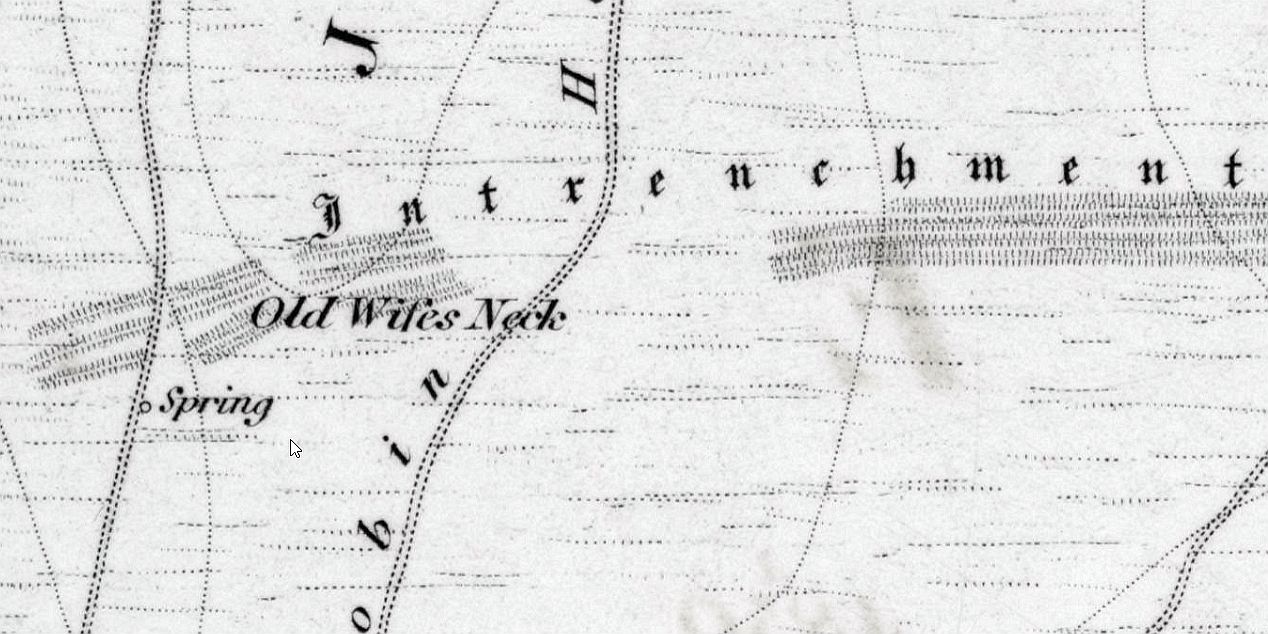
As can be seen on the map above, the first Edition OS map from 1853 does not actually mark the Old Wife’s Neck stone, instead the name is placed on the earthworks themselves. This suggests that when the OS map surveyors were in this area in the mid 1800’s they asked the locals what these earthworks were called, and they were told the ‘Old Wife’s Neck’. However, in a broad rural accent it is quite possible that neck and nick would have sounded almost indistinguishable, and even today in a Yorkshire accent they sound very similar.
Any other Nicks out there?
There are several ‘Nick” place names in the Yorkshire region, and these follow the general pattern of something cut into the landscape. On the western edge of the North York Moors there is Scarth Nick, which is a narrow glacial channel cutting through a hill ridge, and forming a notch or pass through which an old drove road climbs up onto the moors. Sulber Nick is a long sunken trench caused by a fault line, along which a footpath leads up to Ingleborough hill. On a grander scale there is High Cup Nick – an unusual trench-like valley that has been described as the Grand Canyon of the Pennines.
Whatever the name – Old Wife’s Neck or Nick, it is highly likely that there was once a folklore story explaining the Old Wife’s connection to the earthworks, but this has sadly been lost. The stories connected with the Scottish examples of ‘Sgriob na Caillich’ (the Old Wife’s Furrow) include a time when the Cailleach (Old Wife) slid down a hill on her backside and created a wide trench, while on another occasion she ploughed a wide furrow which formed two stony banks either side. In her role as a landscape shaper she is said to have used her hammer or dragged her staff along the ground to create valleys.
In the folklore of the North York Moors, the Old Wife is said to have carried the stones to build the Wheeldale ‘Roman Road’, which is now thought to be a prehistoric structure – possibly a boundary earthwork 1 mile in length. The Old Wife is also associated with the Old Wife’s Trod – a trackway crossing the Gallows Dyke and passing the standing stones at the foot of Blakey Topping – a hill created by her giant husband called Wade. Wade and his ‘Old Wife’ built the castles at Mulgrave and Pickering, both of which sit on large mounds, while there is a reference to the Old Wife sitting on the mound at Pickering to milk her cow. Sadly, only the remnants of these stories remain, stories which would have been full of detail, and in the past would have kept people entertained for hours around the hearth or in the village tavern.
Lost Stories
No doubt there were many other stories which we have no record of – some leaving just a place name like the Old Wife’s Neck. So perhaps in times past, the long ditches running across John Cross Rigg were believed to be another sign of the Old Wife’s activity on the moors. Perhaps she yoked her giant cow to a plough and set off across the rigg, but it was hard going, with large stones being turned up as she ploughed the moor. Even with her giant strength she could only manage 3 furrows before giving up in despair, cursing the stony ground?
Notes
Later revisions of the OS map do mark the Old Wife’s Neck stone on the earthworks.
Before the moorland fire, the ancient earthworks were hidden beneath a blanket of heather and other vegetation. With the heather now burnt away, it provides a rare opportunity to see the structure of the earthworks in detail.
Highly unlikely, but interesting to note the Gaelic word ‘Nic’ means ‘daughter of’. In Scottish folklore, the daughter of the Cailleach (Old Wife) is called Bride, and curiously there are a number of ‘Bride Stones’ on the North York Moors.
Reference
McHardy, S. (2025) Scotland’s Sacred Goddess.
