
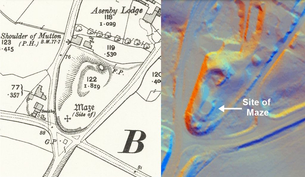
Asenby is a small village located 4 miles to the south of Thirsk. The old Ordnance Survey maps show the site of a maze alongside a crossroads just to the south of the village. Unfortunately, even by the time of the 1890 edition map the maze is marked as ‘site of’ – meaning that it no longer existed at that date. There are however, several old references to the Asenby maze, and this information suggests that it would have been quite a significant feature in the local landscape.
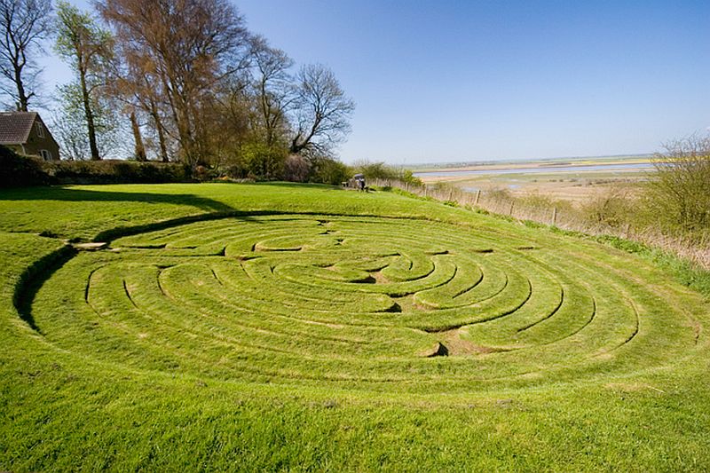
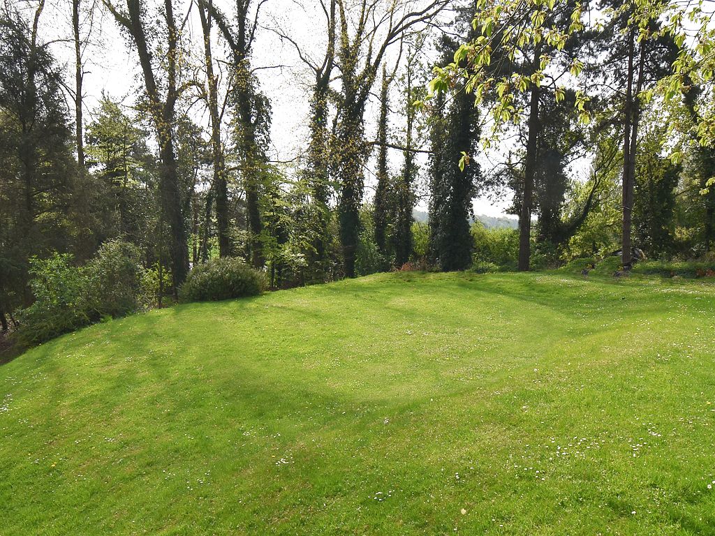
Rather than a hedge type maze, the one at Asenby was a circular turf maze – where the maze design was cut into the ground in a grassed area, creating a winding path which people could follow to the centre of the maze (as shown in the example below).
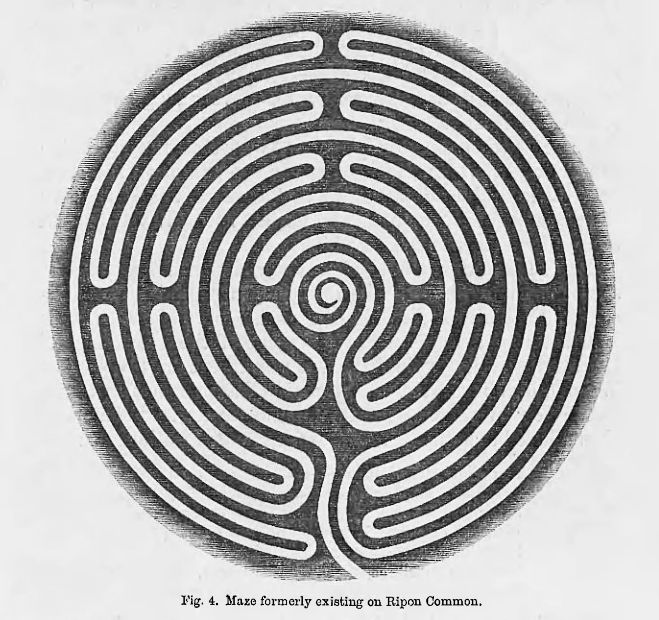
Writing in 1858, Edward Trollope mentions the Asenby maze …
“Another maze, precisely resembling this Ripon specimen, may still be seen in the same locality, namely, at Asenby, in the parish of Topcliffe, and it is preserved with very laudable care at the expense of the parish, and I trust will continue to meet with such attention. It is slightly smaller than the maze formerly to be seen at Ripon, being 17 yards in diameter, and its path is 336 yards long.”
Trollope also included a diagram of the Ripon Maze, and so from this we know what the Asenby design looked like too.
Turf mazes were usually found in rural areas, and seem to have been communal meeting places, sometimes connected with May gatherings and midsummer fairs. At these events people would ‘tread the maze’ – following the winding path to the centre, while sports, dancing, and other pastimes also took place. At other times local children would amuse themselves by running along the path to the centre of the maze and then back out again. Older boys and girls had kissing games where a young man would follow the path to the maze centre and receive a kiss from a girl standing there.
In Edward Trollope’s day (1858), the Asenby maze was being looked after by the parish council, which suggests that it was seen as having some value to the local community, but not long after this the maze seems to have been abandoned for some reason. By the time of the 1890 OS map, the maze is shown as ‘Site of’, and the nearby fence or hedge had been moved to enclose the whole hill. This is confirmed by A.H. Allcroft who wrote in 1908 that the maze at Asenby was almost forgotten …
“There is one at Asenby, in the North Riding, sunk in a hollow at the top of an oval hillock, which to-day looks very like a damaged replica of the ” amphitheatre ” at Charterhouse on-Mendip. Only a very few remain intact, as at Alkborough, in Lincolnshire. It is marvellous that the memory of such things, once prominent features of rural life, can die out so rapidly as it does.”
This is perhaps no surprise as a turf maze requires regular maintenance, with grass cutting and the edges of the pattern also being re cut periodically. If this is neglected it only takes a few years for the design to become overgrown and lost. Allcroft does not mention seeing the maze pattern on his visit, and it is likely that he only saw the remains of the bank around it.
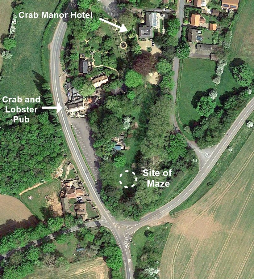
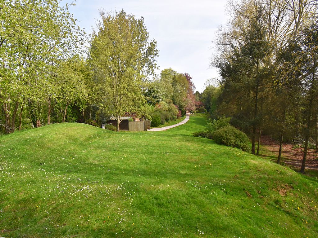
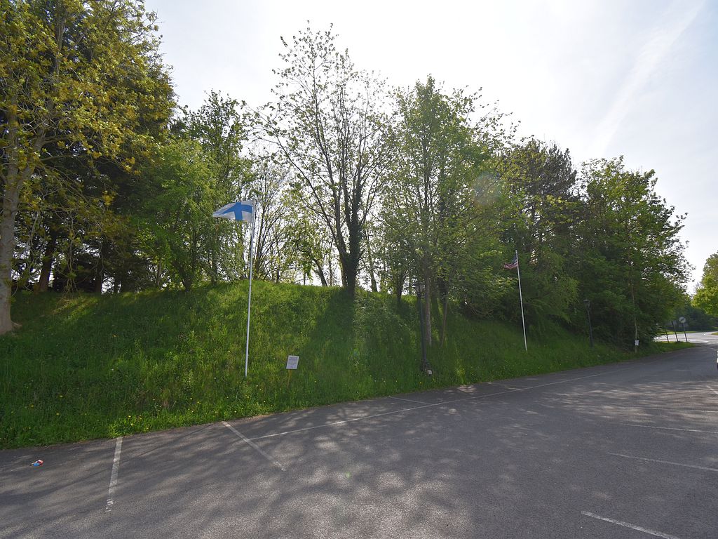
Today, the site of the Asenby maze is located at the bottom of the long garden belonging to Crab Manor Hotel. On a visit to Crab Manor in April 2025 the hotel staff were surprised and interested to learn that there had once been a maze in the garden, and were kind enough to let me take a look around. A tall Pine tree at the very end of the garden stands close to where the old map marks the site of the maze, however, only 10 metres or so away from this tree there is still a flat and circular grassed area with a low bank around it, which looks suspiciously like the maze site at Alkborough.
This would seem to be the actual site of the Asenby Maze, and some conformation of this appears on the Asenby Parish council website where its noted that the maze still exists under the grass at Crab Manor. In recent years this circular feature has been used as a golf putting green, but its shape, size, and location match those recorded for the maze. Edward Trollope measured the maze at 17 yards (15m) in diameter, and the golf green measures exactly the same width across. Allcroft also saw the maze site in the early 1900’s and there was still a low but damaged bank around it – exactly as surrounds the golf green today. While the location is only 10m or so from where the “Site of Maze” is marked on the old OS map. The bank on the north side may have been removed to allow access onto the green, but alternatively this may have been the original entrance to the maze.
The hotel garden runs along the top of a low hillock or raised bank, which is 6 or 7 metres higher than the land around it. The maze was located on the highest part of this ridge, and would have provided quite an extensive view over the surrounding area before the trees grew up around the hill.
And Fairies too!
Although A..H. Allcroft noted that the Asenby maze was almost forgotten, he did find some older residents who remembered it from their youth, and they provided an interesting detail ..
“The Asenby maze is quite unknown to most of the villagers to-day, yet there are persons still alive who will tell one that they have trodden it on many a summer’s evening, and, kneeling down at the centre, have listened ” to hear the fairies singing.” They still call the site the “Fairies’ Hill.”
So the low bank or ‘oval hillock’ where the maze was located was known locally as the ‘Fairies Hill’, from the belief that the fairies lived within the hill. This was quite a common piece of folklore connected with unusual shaped hills, and a similar story is attached to the Pudding Pie Hill at Sowerby – 4 mile to the north east of Asenby. However, the siting of a maze on top of a Fairy hill would seem to be unique. In the past, places associated with the fairies were generally avoided, but here it seems that people gathered on top of the Fairy Hill to ‘tread the maze’, and following the path to its centre they would then listen to hear the fairies within the hill. This is similar to the Pudding Pie Hill folklore where children running around the burial mound nine times would then listen for the fairies singing or speaking within the hill.
These turf mazes are something of a mystery, and raise the question as to why rural communities would go to the effort of creating and maintaining such features in the landscape. Some of the maze designs are thought to be based on a maze laid out on the tiled floor of Chartres cathedral in France. Here the maze is said to have had a religious significance – representing the twist and turns of a persons journey through life and the souls path to heaven. It has also been noted that the cathedral windows allow beams of sunlight to illuminate the maze at certain times of the year, which might point to the circular maze also being a symbol of the sun, This sun symbolism perhaps ties in with the midsummer fairs taking place at turf mazes, where people would walk or run the winding path to the centre. These circling activities were perhaps connected with older beliefs about the sun and certain hills or burials mounds, and spirits (fairies).
So even after 150 years it appears that the site of the Asenby maze still survives, although the maze pattern itself has merged back into the turf. It is just possible that carefully removing the turf may reveal the pattern in the soil below, but this sounds more like a job for the Time Team!
References
Allcroft A.H. (1908) Earthworks of England.
Trollope. E. (1858) Turf and Hedge mazes Archaeological Journal vol 15
OS maps at the National library of Scotland
Crab Manor Hotel
After notes
The Asenby maze is not marked on the first edition OS map of 1853, although we know from Edward Trollope that it existed at that time. This is not unusual, as the first OS map surveyors are known to have made some errors, and missed features that were corrected on later edition maps. The old turf maze at Dalby was still not marked on the paper OS maps even in 2006.
Allcroft mentioned the Asenby maze being in a circular sunken hollow or ‘amphitheatre’, which has been noted at other maze sites, and was perhaps formed when the ground was levelled up before the maze was cut. It has also been suggested that many years of use, as well as cleaning and re cutting a maze would gradually sink it into the ground, and so this could be a sign that the maze had been in existence for a long time.
The road passing alongside the maze hill and Asenby village is now a fairly quite rural road. However, before the A1 was built this was actually the Great North Road, which passed through Topcliffe. So the maze was originally located at a crossroads on the main north south route through England. At the crossroads were two inns and a blacksmiths shop catering for the passing traffic, while the maze was located on the low hill next to the inns.
The fate of the maze?
In the late 1850’s the Asenby maze was being looked after by the parish council. However in the years soon after this the maze was abandoned, and the area fenced off. What could have caused the parish council to take this action?
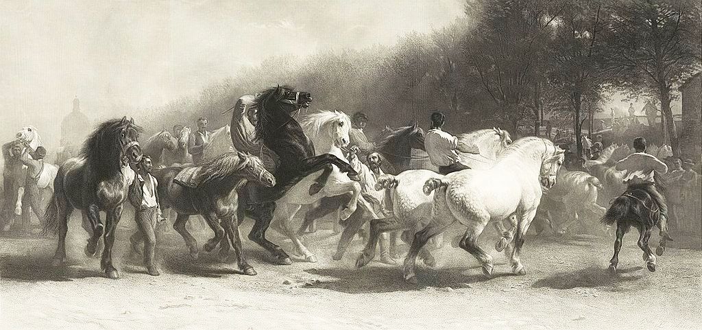
Asenby was originally part of the Topcliffe parish, with Topcliffe village located less than half a mile to the north of Asenby. Topcliffe’s claim to fame is that it was the location where the famous (or infamous) Topley Fair was held for generations. This was one of the largest horse fairs in the north of England, and was held over several days in mid July, every year. Sheep as well as horses were bought and sold at the fair, while hundreds if not thousands of people came to the fair for the markets stalls and fairground attractions.
Although the fair officially took place in Topcliffe village, the proceedings seem to have spilled out into the surrounding area, with the encampments of Gypsies and horse dealers extending down the road to the fields around Asenby village. Drinking booths were apparently setup on the roadside here, and horses were run along the road as part of the trading.
The fair also attracted a ‘rough element’ which led to it having a reputation for drunkenness and fighting. Thieves and pickpockets were also present, and local villagers were among the victims, being either attacked, or their property stolen or damaged. There was also a ‘tradition’ of people going to Topley Fair to settle grudges and arguments with a fist fight. There was even a field set aside for women to fight in, and this was all probably seen as part of the fair’s ‘entertainment’, along with illegal drink, gambling and cockfighting etc. Topcliffe village appointed two wardens armed with pikes to patrol the main part of the fair to keep law and order, but it is unlikely that they ventured down into the encampments around Asenby village.
The presence of the wardens on the main fair site may well have led to the rougher element congregating down the road at Asenby for their more dubious activities. Here at the crossroads next to the maze were two pubs and blacksmiths shop, so it is quite likely that the crossroads area was a gathering place for drinking and horse trading. With the circular maze located on the low hill just next to the crossroads it is easy to picture this concealed area being used as a ring for fist fights or cock fighting.
Although the fair had existed for many years, it may have grown in popularity in the late 1800’s, attracting crowds from the industrial areas in the region. This expansion would explain the negative impact on the Asenby villagers nearby, who complained and petitioned for the encampments to be moved back to Topcliffe. The Asenby land owners also made a pact not to let fairgoers onto their land in order to keep them away from the village. It is also worth noting that by the time of the 1890 OS map, the pub nearest the crossroads had also closed down as well as the maze having disappeared and its location fenced off . So this may have all been part of the Asenby residents attempt to put an end to the problems associated with fair.
