
The City of Troy is the name of a Turf maze located on the grass verge alongside Bonnygate Lane, 1 mile to the north west of Dalby – a small hamlet on the Howardian Hills, 12 miles to the north of York.
A previous post looked at the site of the lost turf maze at Asenby near Thirsk, however the maze at Dalby still exists in good condition, and its roadside location means that it can be easily visited. At only 6 metres in diameter it is the smallest surviving turf maze in Britain, although the size is limited by the width of the grass verge where it is located.
In common with other turf mazes, there is very little known about the Dalby maze, and it seems that the mainly rural locations of these grass cut features made it unlikely that they would be recorded in old documents. Turf mazes do however appear to have been quite common in the past, and even get a mention in Shakespeare’s ‘A Midsummer Night’s Dream’ written in the late 1500’s. The small number of old references suggest that the mazes were gathering places for rural pastimes or small fairs – where games, sports, and dancing etc took place. It seems likely that the spread of the industrial revolution led to their decline in the early 1800s – with some surviving in more rural areas, while most were left to become overgrown and lost, or actually destroyed – like the maze near Ripon which was ploughed over in 1827.

The few details we have about the Dalby Maze appear in an article by T.J. Mitchell, which was printed in the Transactions of the Scarborough and District Archaeological Society (Vol1 No5 1962) …
“The enigma of the Dalby maze was largely unravelled a few years ago by Mr, C. J. Taylor, a member of the Scarborough & District Archaeological Society, when he spent several days in the locality interviewing old residents in an endeavour to gain first-hand information regarding the maze, especially with reference to the period just prior to its adoption by the County Council in 1930.
Mr. Taylor learned authentically that the maze was dug on its present site as late as 1900, replacing an identical cutting made about 1860 which was a little to the west of the present position and had been badly damaged by horses hooves and farm waggons. This information was given by Mr. Robert Myers, a former roadman who was then living at Skewsby post office nearby and was at that time 80 years of age. Mr. Myers also said that his grandfather had recalled that the 1860 cutting had been copied from a carving on a barn door at Skewsby at a time when the Dalby maze was not discernible on the ground.
It seems reasonable to assume therefore that the door-carving was the means, deliberate or otherwise, of perpetuating the traditional design of a succession of ancient mazes, originating possibly in Viking times. The immediate locality was certainly well and truly colonised by the Danes, as indicated in the ”-by” suffixes of all the nearest villages – Dalby, Skewsby, Brandsby, Stearsby, and so on.”
The details above point to the Dalby maze having been in existence for quite some time prior to 1860, but like other turf mazes at that date it had become totally overgrown and neglected, and had to be recut from the pattern which was carved into a barn door at Skewsby. Skewsby is the second hamlet making up the parish of Dalby Cum Skewsby, and is actually slightly closer to the maze than Dalby. The fact that a pattern or ‘template’ for the maze was kept at a farm in Skewsby might suggest that there was a local family there who were the traditional custodians of the maze. (The 1856 OS map shows that there were only two farms in Skewsby at that time – Manor House Farm and Town End farm). By 1900 the maze had again become almost lost due to horse and carts running over it, and with the ground so damaged, it was decided to re-cut the maze pattern a little to the east of the old one.

Anyone visiting the Dalby maze will notice the extensive views from the site, especially to the south across the Vale of York. This appears to have been intentional as the maze is located some distance from the two hamlets, and sits on a ridge forming the highest ground in the parish – providing an almost 360 degree panoramic view. (The maze at Asenby was also located on a low hill outside the village, which allowed views across the surrounding countryside). The location of the Dalby maze is also only 100m from the parish boundary with Brandsby and Stearsby, so this may have been chosen as a more central place where villagers from the different parishes could meet at certain times of the year, perhaps for general gatherings or even a small fair. Such parish gatherings often had their roots in medieval religious celebrations, and it is worth noting that mazes also feature in Christian symbolism, where the pattern represents the twist and turns of a persons journey through life, and the souls path to heaven.

This Christian connection was also noted by Mitchell …..
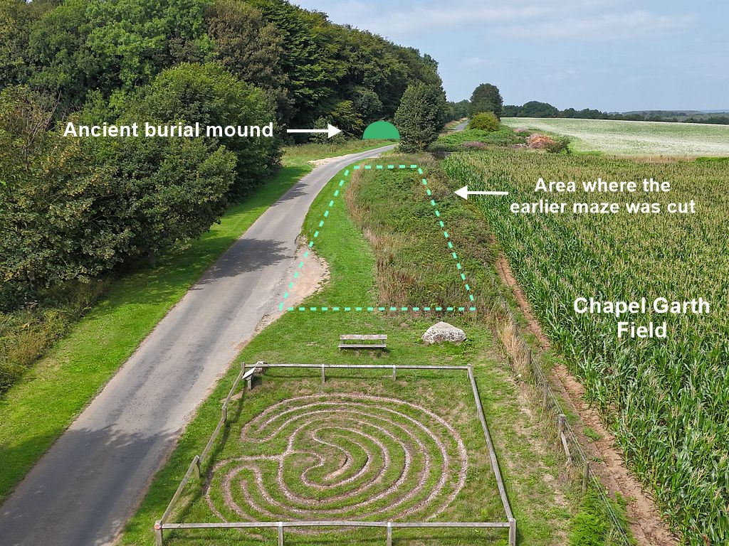
“Many of the English mazes, it is pointed out, were adjacent to churches or stood on ground owned by the Church. In this connection it is interesting to note that the land immediately behind the City of Troy at Dalby is still known as Chapel Garth, although no trace remains today of a place of worship there”.

There are other examples where the field name ‘Chapel Garth’ is known to mark the site of a lost medieval chapel, and so this raises the intriguing possibility that the Dalby maze was originally associated with a wayside chapel. If this was the case then this chapel and turf maze stood alongside Bonnygate lane on a hill ridge with spectacular views over looking the Vale of York. Again, it is worth noting that in the woodland by the roadside 200m west of the maze there is an ancient burial mound, which was probably also placed on the same ridge of high ground because it provided views over the surrounding landscape.

Bonnygate is a curious name, with Bonny being a northern word meaning nice or pretty, but it seems unlikely that this referred to a particularly attractive gate somewhere along this lane. It is more likely that the ‘gate’ comes from the older Norse word Gata – meaning a road, but again old roads are rarely described as attractive or pretty. There is however another old Norse word ‘Bon’ which meant to pray, praying or petition, and this might be more relevant if a chapel once stood alongside the road. As Mitchell noted, the villages in this area were established by early Scandinavian settlers, so the Bon word would be part of the language in this relatively isolated upland area. However, it is likely that these early settlers brought their pre-Christian religion with them – worshipping the Norse gods Odin, Thor, and Freya etc. so this would probably pre date any Christian chapel in the area. These settlers did however use hills and ancient burial mounds as gathering places where matters of law, justice, and local politics were decided, with religious rites also taking place at these ‘Haugr’ or sacred mounds.

These Haugr mounds were also the location used for Utiseta rituals – where a person would visit the mound to seek answers from the spirits dwelling within (see the Nanny Howe post). In this case the word Bon – meaning to petition, pray, or request, would perhaps be even more relevant. It has been suggested in other posts on this site that places like Roseberry Topping, Freeborough Hill, Hood Hill, and Hollin Hill at Hovingham were sacred hills used by these early Scandinavian settlers, and that these sites perhaps formed a chain around the edge of the North York Moors uplands. In areas where there were no significant natural hills, ancient burial mounds may have served as the Haugr, so perhaps the burial mound alongside Bonnygate Lane with its dramatic out look over the Vale of York served as the Haugr for this area.
The ‘pagan’ use of pre Christian sites was a real problem for the early church, and they often took steps to Christianise such locations with either a cross or a chapel or even a church ( e.g. the Rudston monolith). If the Bonnygate burial mound had long been used as a Haugr site for the settlements in this area, then these activities might explain why a chapel came to be built in this fairly remote location.
Traces of folklore?
In his article T.J. Mitchell noted that …
“As might be expected, various superstitious beliefs and practices became associated with the mazes in rural England. It is said, for instance, that in some cases the rings were cut as a charm on unfertile ground, or to dispel the Evil One from bewitched land.”
Mitchell also mentions that on a visit to the Dalby maze a local youth told him that it was unlucky to walk more than 9 times around it. Why it was unlucky is not explained, but elsewhere it was believed that running around an ancient site 9 times would cause the Devil to appear. At Asenby children ran around the maze to its centre where they knelt down to listen for the fairies singing inside the hill, however it was more generally believed that contact with the fairies brought bad luck. Like wise at the Pudding Pie Hill burial mound near Thirsk, anyone running around the mound 9 time might hear the fairies talking inside the mound. In this respect it is again worth noting the large burial mound 200m to the west of the Dalby maze, so there may have once been similar folklore connected with this area around the burial mound and the maze. Running or walking around these features a set number of times hint at some old folk ritual performed to gain good ‘luck’ (or at least prevent bad luck/misfortune) which ties in with Scandinavian beliefs where such mazes were said to trap bad spirits (fairies?) who caused bad luck.
With the lack of any other recorded history, much of the above can only be speculation, but there is an old reference to a hermitage chapel on Roseberry Topping, whose old name was Odin’s hill, which suggests that it required a Christian presence on the hill top, and a holy well and chapel on the path to it. The site of the isolated church at Dalby may have also been chosen because there was a pre existing pagan site at that location – in the form of a large spring flowing from a hollow below the church on its south side. This spring is actually within the churchyard, and the stream flowing from it runs towards the south (a south flowing spring) – a quality which was believed to give the water healing powers in the old folk religion. So this may be another example where there was a holy well and chapel along the road leading up to a holy hill or Haugr site.

Mitchell and others have suggested that these turf mazes were a tradition brought to Britain by Viking settlers, so the Dalby turf maze on a hill near an ancient burial mound may have had its roots in very old beliefs. Even the City of Troy name at Dalby is derived from the ‘Trojaborg’ (Troy-berg) mazes found in Scandinavian countries – with more than 300 Trojaborg sites recorded in Sweden.
What ever the history behind the Dalby turf maze, it is a ‘amazing’ that it still exists when so many others have been lost. This old traditional site in a peaceful location is well worth a visit, and there is even a bench to sit a while and contemplate the maze. If you are tempted to follow the path to the centre – remember – no more than 9 times!
After Notes
Although referred to as the Dalby turf maze, Skewsby probably has a better claim to it. Skewsby is closer to the maze, and while the Dalby hamlet has the parish church, there are only four isolated houses there. Skewsby on the other hand is actually more of a small village. Skewsby was also the location of Manor House Farm and the Manor Barn, so it was probably the centre of a medieval estate, and this barn may well have been where the pattern for the maze was kept – carved into the barn door.
In connection with the Bonnygate name, it is interesting to note that the fields to the east of the maze site at Asenby are called Bonny Carr.
In the 11th century, the lands at Dalby were given to St Mary’s Abbey in York, so any lingering pagan activity in the area may have come to the churches attention. If the burial mound was still being used as a Haugr site by the local population, then this may have led to a chapel being built nearby with a dedication to an appropriate saint. If the maze also existed at that time, then its Christian symbolism would allow its continued use in the devotional practices and prayers connected with the chapel.
The Trojaborg mazes found in Scandinavia are also called Jungfrudans or Maiden’s Dance, which may have originally been a kind of fertility ritual. For this custom a young woman would stand in the centre of the maze while a young man would follow the winding path to the centre and ‘rescue’ her – leading her back out along the maze path. The belief that bad spirits or bad luck could be trapped within these kind of mazes would then ensure good fortune for their future together. It is suggested that this ritual led to the mazes being later connected with the City of Troy – from the Greek legend of the beautiful Helen being retrieved from the supposedly impregnable fortress of Troy. Trojaborg does actually means ‘Troy Fortress’.
The recorded folklore about the Fairies voices being heard at the Asenby maze hill and the Pudding Pie burial mound might just be a faint memory of some folk divination practices like the Utiseta ritual, where people slept or meditated on a burial mound, and the spirits within ‘spoke’ to them. As the faerie folk are thought to have originally been ancestor spirits, this would seem to fit with such folk practices. It has also been suggested that on one level the ancient maze pattern represents the path or journey to the Otherworld, which a person would undertake while in a meditative or trance state. Tracing out the maze pattern before they entered that state could have been a kind of psychological safety line, in case they became overwhelmed or lost.
Reference
T.J. Mitchell. (1962) Transactions of the Scarborough and District Archaeological Society (Vol1 No5)
